SensFish Marine Restoration Monitoring and Environmental Intelligence Platform

The Challenge

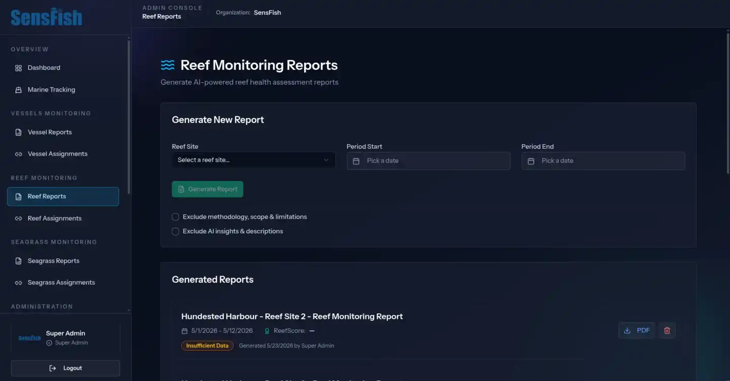
Artificial reef restoration is growing rapidly across European waters, but the tools to measure whether these investments are actually working have not kept pace. Reef performance is typically judged from dive surveys that arrive months apart, cost a small fortune to schedule, and produce snapshots that miss the continuous environmental dynamics that determine whether a reef thrives or fails.

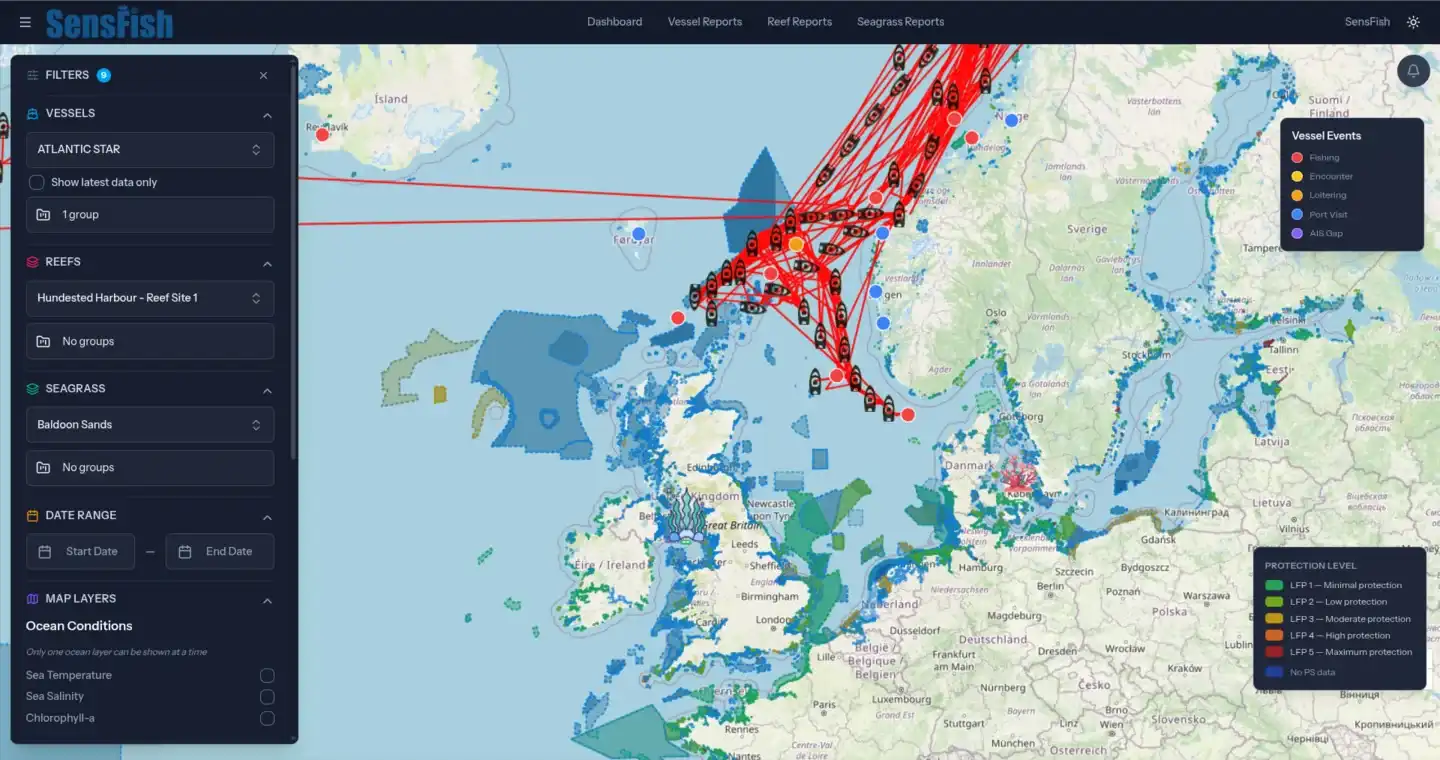
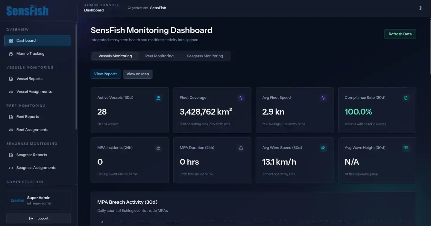
At the same time, fisheries compliance teams operate from an entirely separate set of tools. Vessel activity is tracked in one system, marine protected area boundaries in another, and biodiversity data in a third. There is no shared framework that connects reef health evidence with vessel pressure data.

To address this challenge, SensFish Ltd, a UK marine intelligence SME, is developing proprietary environmental intelligence infrastructure for fisheries, coastal ecosystems, and marine restoration applications.

In this project, SensFish led the planning and the development of a scalable restoration intelligence capability integrating satellite Earth Observation, environmental monitoring, vessel activity visibility, biodiversity information, and geospatial analytics within a unified operational interface.

Working alongside the SensFish internal technical and environmental intelligence team, Astro42 contributed to selected engineering and implementation components of the wider SensFish environmental intelligence platform, including aspects of geospatial interface development, dashboard functionality, environmental and vessel activity data integration, and operational reporting workflows.

The project aimed to support more integrated and operationally accessible environmental visibility for marine restoration stakeholders based in Denmark, enabling improved monitoring, environmental reporting, ecosystem assessment, and vessel activity awareness across complex coastal and offshore environments.

Coral reef ecosystem — SensFish marine restoration and biodiversity monitoring

The Solution

The resulting SensFish environment enables users to access integrated environmental observations, operational trend visibility, vessel activity awareness, site-level monitoring outputs, and reporting tools through a unified operational interface designed for restoration assessment, environmental reporting, and stakeholder communication.

Particular focus was placed on improving environmental visibility and operational accessibility across dynamic marine environments where monitoring conditions, environmental variability, and data availability can vary significantly. The SensFish platform integrates multiple environmental data layers, vessel activity datasets, and confidence-aware processing workflows to maintain transparency in how observations and outputs are presented.

Astro42's engineering contribution combined deep expertise in geospatial systems, satellite data engineering, and full-stack platform development. The team contributed to the dashboard's interactive mapping layer for reef sites, vessel tracks, and protected area boundaries, provided the expertise for building data integration workflows across satellite Earth Observation, in-situ environmental measurements, vessel tracking sources, and biodiversity records, and supported the implementation of the spatial engineering required to process vessel positions against global protected area datasets at operational scale.

The SensFish solution also supports forward-looking environmental monitoring capabilities and automated reporting workflows designed to assist restoration stakeholders, environmental programmes, marine management teams, and long-term monitoring activities.

SensFish interactive map showing vessel tracks, reef sites, seagrass areas, and marine protected area boundaries

The Result

In this project, Astro42 supported the continued expansion of SensFish Ltd's coastal habitat intelligence capabilities, delivering a clean, intuitive and smooth user interface and experience tailored to the workflows of restoration stakeholders and analyst teams. It also supported the continued expansion of SensFish Ltd's marine restoration and environmental intelligence capabilities, enabling restoration stakeholders, environmental teams, and marine management organisations to access more integrated environmental and operational visibility through a unified geospatial monitoring environment.

Together with SensFish internal intelligence team, Astro42 contributed selected engineering and platform development components supporting geospatial monitoring, environmental and operational data integration, dashboard functionality, and reporting workflows within the wider SensFish environmental intelligence platform.

The resulting technological layer supports integrated environmental observations, vessel activity visibility, monitoring outputs, and reporting workflows designed to assist restoration assessment, stakeholder communication, environmental reporting, and operational marine monitoring activities across complex coastal and offshore environments.

The project also contributed to the development of scalable technical workflows for integrating Earth Observation, environmental monitoring, biodiversity information, and vessel activity data within marine restoration and environmental management applications, supporting future long-term ecosystem monitoring, restoration initiatives and stakeholder reporting use cases.

SensFish monitoring dashboard with vessel activity, fleet coverage, compliance rate, and marine protected area breach metrics
SensFish reef monitoring reports — AI-generated reef health assessment reporting for restoration assessment and stakeholder communication

Project tech stack

React JavaScript library

React

Laravel PHP framework

Laravel

PostgreSQL / PostGIS spatial database

PostgreSQL / PostGIS

Tailwind CSS framework

Tailwind CSS

Python programming language

Python

Long-term Wins

Continued expansion of SensFish Ltd's marine restoration and environmental intelligence capabilities, with the project supporting scalable operational intelligence solutions for restoration and fisheries compliance contexts.
Improved accessibility of integrated environmental and vessel activity visibility for marine restoration assessment and operational monitoring activities.
A sustainable engineering foundation for integrating Earth Observation, vessel tracking, biodiversity records, and protected area data within marine intelligence applications.
Enhanced capability for forward-looking environmental monitoring and operational awareness across complex marine environments.